Mt Fuji Height — The Definitive Measurement
Mt Fuji stands at 3,776 meters (12,389 feet) above sea level, making it the tallest mountain in all of Japan. Its peak, known as Kengamine (剣ヶ峰), sits on the southwestern rim of the volcanic crater and represents the official highest point as surveyed by the Geospatial Information Authority of Japan (GSI). For travelers, mountaineers, and geography enthusiasts searching for the Mt Fuji height, this is the single most important number to know — and the story behind it is far more fascinating than a simple statistic.
-

-
Mt Fuji: The Ultimate 2026 Guide to Japan's Iconic Mountain
Why Mt Fuji Captivates Millions of Visitors Every Year Mt Fuji — or Fujisan (富士山) as it is known in Japanese — stands at 3,776 meters (12,389 feet), making it the tallest peak in Japan. Its near-perfect symmetrical cone, capped with snow for much of the year, has been a symbol of Japan for centuries. In 2013, UNESCO designated Mt Fuji as a World Cultural Heritage Site, recognizing not just its geological significance but its deep influence on Japanese art, literature, and spirituality. Whether you want to climb to the summit, photograph the mountain from a picturesque lake, soak in ...
続きを見る

Mt Fuji Height in Different Units
Depending on your country of origin, you may be more comfortable with one unit system over another. Here is a quick reference table for the height of Mt Fuji expressed in every common measurement:
- Meters: 3,776 m
- Feet: 12,389 ft
- Kilometers: 3.776 km
- Miles: 2.346 mi
- Yards: 4,129.5 yd
The figure of 3,776 meters is derived from the most recent high-precision GPS survey and is the value recognized internationally. You will sometimes encounter the rounded figure of 3,776.24 meters in scientific literature, but 3,776 m is the standard reference.
How Mt Fuji's Height Was Measured Through History
Japan's relationship with measuring Mt Fuji stretches back centuries. During the Edo period (1603–1868), scholars attempted to estimate the mountain's height using rudimentary triangulation methods, though results varied widely. It was not until modern geodetic surveying arrived in the Meiji era that precise measurements became possible.
Early Surveys and the Meiji Era
The Imperial Japanese Army Land Survey Department conducted the first reliable triangulation survey in the late 19th century, establishing Mt Fuji's height close to the figure we recognize today. By the early 20th century, the official height was listed as 3,776 meters, a figure that has remained remarkably stable through subsequent resurveys.
Modern GPS Verification
In 2014, the Geospatial Information Authority of Japan used high-precision GPS equipment to re-verify the elevation. The result confirmed 3,776 meters as the accurate height of the Kengamine summit. This measurement accounts for the geoid — the theoretical shape of the Earth's gravitational field at sea level — ensuring accuracy that earlier triangulation methods could not achieve.
Why Is Mt Fuji Exactly 3,776 Meters?
Mt Fuji is a stratovolcano, meaning it was built up over tens of thousands of years through successive layers of lava, volcanic ash, and pyroclastic material. Its current height is the product of three overlapping volcanic cones:
- Komitake: The oldest layer, dating back roughly 700,000 years
- Ko-Fuji (Old Fuji): Formed approximately 100,000 years ago
- Shin-Fuji (New Fuji): The most recent cone, which began forming about 10,000 years ago and gave the mountain its current symmetrical profile
Each eruption cycle added material, gradually raising the summit. The last recorded eruption in 1707 — known as the Hōei Eruption — did not significantly alter the peak's height but did create the prominent Hōei crater visible on the southeastern flank. Since that eruption, weathering and erosion have been the primary forces shaping the summit, though they operate at an extremely slow rate on volcanic rock.
How Mt Fuji Compares to Other Famous Mountains
At 3,776 meters, Mt Fuji is impressively tall but modest compared to the world's highest peaks. Here is how it stacks up:
- Mt Everest (Nepal/China): 8,849 m — more than twice the height of Fuji
- Mont Blanc (France/Italy): 4,808 m — about 1,000 m taller
- Mt Kilimanjaro (Tanzania): 5,895 m — roughly 2,100 m taller
- Mt Rainier (USA): 4,392 m — approximately 600 m taller
- Mt Fuji (Japan): 3,776 m
- Mt Kita (Japan): 3,193 m — second tallest in Japan, nearly 600 m shorter
What makes Mt Fuji extraordinary is not absolute height alone but its prominence. Because it stands as an isolated peak on the Kantō Plain rather than as part of a continuous mountain range, it rises dramatically from near sea level, giving it a visual impact that rivals peaks far taller on paper.
Prominence vs. Elevation: Why Fuji Looks So Tall
Topographic prominence measures how much a mountain rises above the surrounding terrain before you encounter higher ground. Mt Fuji's prominence is approximately 3,776 meters — identical to its elevation, because no higher ground exists between Fuji and the distant peaks that surpass it. This makes it one of the most prominent peaks in the world and explains why it dominates the horizon from over 100 kilometers away on clear days.
For comparison, a 4,000-meter peak in the Alps may have a prominence of only 1,000–2,000 meters because neighboring mountains rise nearly as high. Fuji's isolation is the key reason it appears so imposing from Tokyo, Yokohama, and even the Shizuoka coastline.
Best Viewpoints to Appreciate Mt Fuji's Full Height
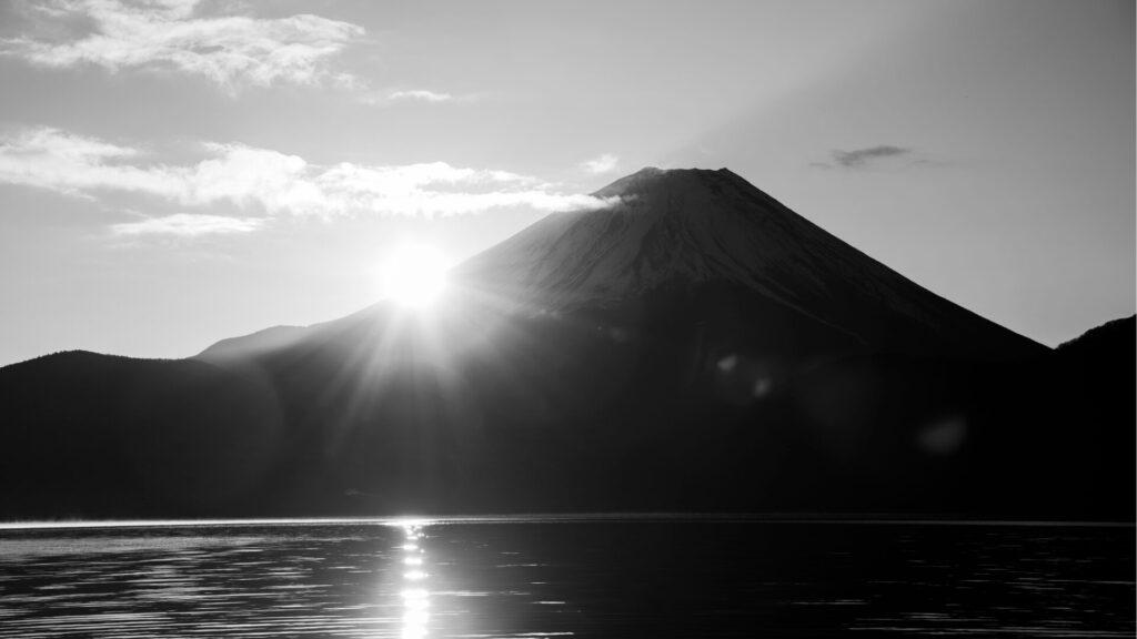
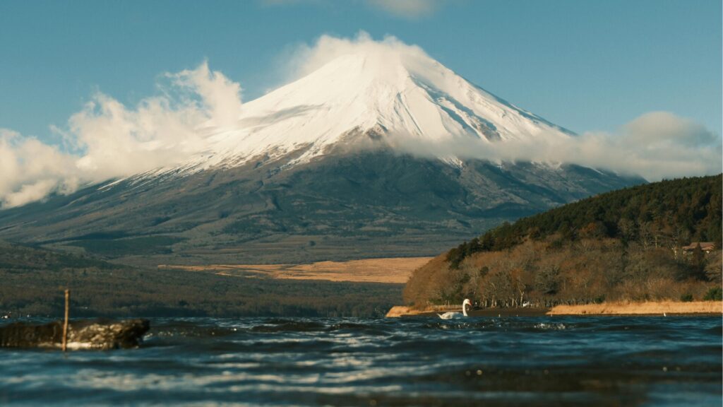
Seeing Mt Fuji from a distance is one of the most sought-after experiences in Japan. To truly appreciate its 3,776-meter stature, you need a viewpoint that showcases the mountain from base to summit with minimal obstruction.
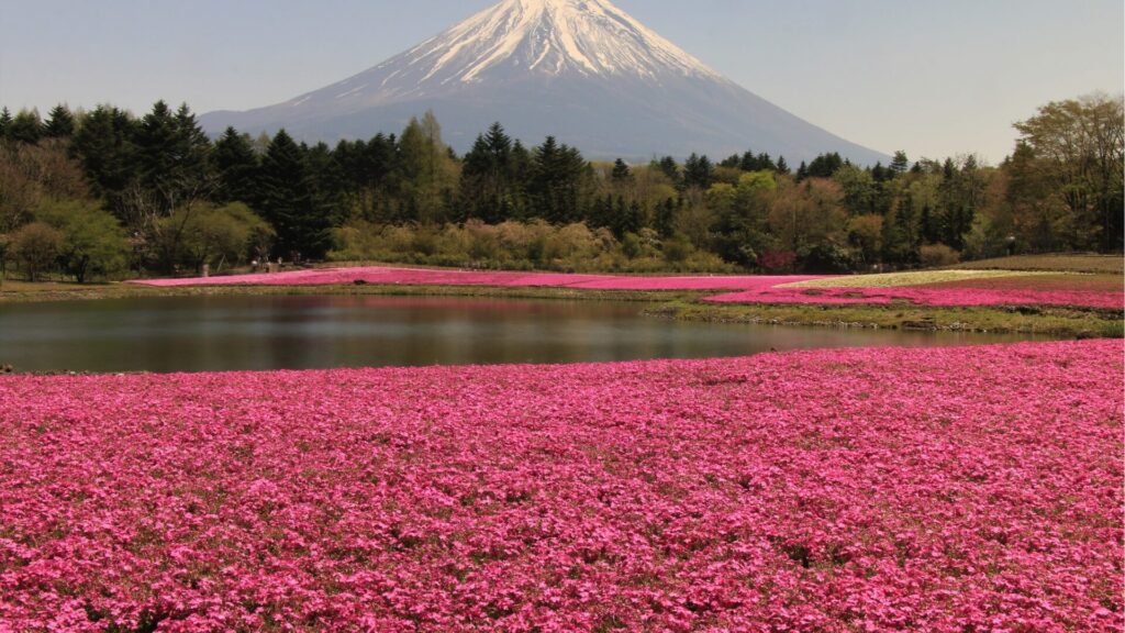
Kawaguchiko (Lake Kawaguchi)
The northern shore of Lake Kawaguchi sits at roughly 830 meters elevation, meaning you can see nearly 3,000 meters of vertical rise from the lakeshore to the summit. Reflections of the peak on the lake's surface on calm mornings are legendary among photographers.
-
-
Drive from Tokyo to Kawaguchiko Onsen: The Ultimate Self-Drive Guide for Overseas Visitors
Planning to drive from Tokyo to Kawaguchiko onsen? This in‑depth guide covers routes, permits, parking, tolls, itineraries, and seasonal tips—everything you need to enjoy Lake Kawaguchiko and Mt. Fuji hot springs by rental car. Why Drive from Tokyo to Kawaguchiko Onsen? Driving gives you freedom to stop at scenic viewpoints, lesser‑known onsen ryokan, and cafés around the Fuji Five Lakes. Compared with trains and buses, a car lets you combine multiple sights in one day, travel early or late to avoid crowds, and carry luggage with ease. Quick Facts Distance & time: ~110–140 km from central Tokyo; 2–2.5 hours in ...
続きを見る
Miho no Matsubara (Shizuoka)
This UNESCO-associated pine grove along Suruga Bay offers a sea-level perspective of Fuji, letting you see the full 3,776 meters of rise. The combination of ocean, pine trees, and the towering volcano is a classic ukiyo-e composition immortalized by Hiroshige.
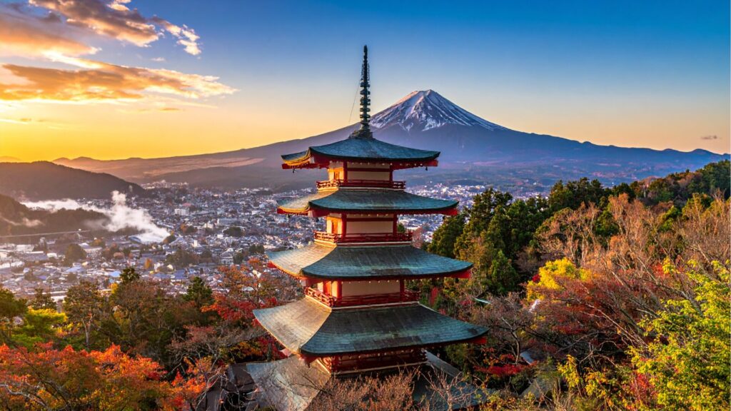
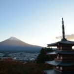
Chureito Pagoda (Fujiyoshida)
The iconic five-story pagoda with Mt Fuji in the background provides a cultural foreground that emphasizes the mountain's scale. The pagoda viewing platform sits at approximately 900 meters elevation.
Driving Routes
For those exploring the Fuji Five Lakes region by car, the Subashiri and Fuji Skyline routes offer continuously changing perspectives of the mountain's height as you gain and lose elevation through forested switchbacks.
Does Mt Fuji's Height Change?
Technically, yes — but imperceptibly. Several factors influence the summit elevation over geological time:
- Volcanic activity: If Mt Fuji erupts again, lava and tephra deposits could increase the height. Conversely, a catastrophic eruption could collapse part of the summit.
- Tectonic movement: Japan sits at the junction of four tectonic plates. Crustal uplift or subsidence can shift elevations by millimeters per year.
- Erosion: Wind, rain, and freeze-thaw cycles slowly wear down exposed rock at the summit, though the rate is negligible over human timescales.
- Snow and ice: Seasonal snowpack can add several meters of apparent height in winter, but official elevation measurements reference the rock surface, not snow.
Barring a major eruption, the 3,776-meter figure will remain accurate for the foreseeable future.
The Significance of 3,776 in Japanese Culture
The number 3,776 has taken on cultural significance in Japan. It appears on commemorative stamps, is used in trivia competitions, and serves as a popular mnemonic in Japanese schools. Students often learn the phrase "mi-na-na-ro" (みなななろ), a phonetic memory aid that maps to 3-7-7-6 in Japanese wordplay.
Mt Fuji's designation as a UNESCO World Cultural Heritage Site in 2013 further cemented the mountain's height as a globally recognized figure. The UNESCO listing specifically recognized Fuji as a cultural — not natural — site, acknowledging centuries of artistic and spiritual reverence tied to its towering, symmetrical form.
Climbing to the Summit: Experiencing 3,776 Meters Firsthand
The official climbing season runs from early July to mid-September, when all four major trails are open and mountain huts are staffed. Reaching the 3,776-meter summit on foot typically takes 5–8 hours ascending and 3–5 hours descending, depending on the route:
- Yoshida Trail: Most popular, starting from the 5th Station at 2,305 m — a 1,471 m vertical gain to the summit
- Subashiri Trail: Starts at 1,970 m with a 1,806 m climb through forest
- Gotemba Trail: Longest route, beginning at 1,440 m — a full 2,336 m ascent
- Fujinomiya Trail: Shortest distance but steep, starting at 2,380 m
As of 2026, climbers must register online and pay a mountain conservation fee. Capacity limits are enforced on the Yoshida Trail during peak weekends to protect both the mountain environment and visitor safety. Altitude sickness becomes a real concern above 3,000 meters, so proper acclimatization is essential regardless of fitness level.
-
-
Climbing Mt Fuji in 2026: The Complete Guide to Routes, Seasons, and What to Expect
Why Climbing Mt Fuji Should Be on Your Japan Bucket List Standing at 3,776 meters (12,389 feet), Mt Fuji is Japan's tallest peak and one of the most iconic mountains on Earth. Every summer, hundreds of thousands of hikers from around the world converge on its slopes to experience the once-in-a-lifetime thrill of climbing Mt Fuji. Whether you are drawn by the spiritual significance, the legendary sunrise from the summit, or simply the challenge of conquering an active stratovolcano, this guide covers everything you need to know about climbing Mt Fuji in 2026. The 2026 Climbing Season: When Is Mt ...
続きを見る
Frequently Asked Questions About Mt Fuji's Height
Is Mt Fuji the tallest volcano in Asia?
No. While Mt Fuji is Japan's tallest peak, several volcanoes in the Kamchatka Peninsula (Russia) and Central Asia exceed its height. Klyuchevskaya Sopka in Kamchatka, for instance, reaches 4,750 meters.
Has Mt Fuji always been 3,776 meters?
No. The mountain has grown through multiple eruptive phases over hundreds of thousands of years. Its current height was largely established by the Shin-Fuji volcanic cone within the last 10,000 years.
Could an eruption change Mt Fuji's height?
Absolutely. A future eruption could either add material to the summit or cause a partial collapse. Volcanologists consider Mt Fuji an active volcano, and the Japan Meteorological Agency continuously monitors it for signs of unrest.
Why do some sources say 3,775 meters or 3,778 meters?
Older survey data, rounding differences, and whether snow cover was included in the measurement can produce slight variations. The official, GSI-verified figure is 3,776 meters.
Key Takeaways
Mt Fuji's height of 3,776 meters (12,389 feet) makes it the undisputed tallest mountain in Japan and one of the most visually prominent peaks on Earth. This elevation is the result of hundreds of thousands of years of volcanic activity across three overlapping cones, confirmed by modern GPS surveying. Whether you are planning to climb to the summit, photograph the peak from the Fuji Five Lakes, or simply want to know the answer to a geography question, the number 3,776 is the definitive figure — a number deeply woven into Japanese culture and recognized around the world.
Experience Japan’s Finest JDM Adventures

From Daikoku PA tours to JDM sports car rentals and drift experiences, we offer premium driving adventures for visitors who want more than ordinary sightseeing.
Get behind the wheel of iconic machines such as the GT-R, RX-7, and Supra, and experience Japan’s legendary car culture in the most unforgettable way. Whether you want a scenic Tokyo car experience or something more thrilling and immersive, we can guide you to the right plan.
Not sure which experience suits you best? No problem. Message us on WhatsApp and we’ll help you choose the ideal option based on your travel plans, interests, and driving experience.
Popular dates sell out quickly, so we recommend contacting us early.
Customer Reviews

Important Information
- This is a drive tour where you drive your rental car, and our guide navigates from the seat.
- This is a self-drive tour where you drive your rental car, and our guide navigates from the passenger seat.
- The tour begins and ends at the same location (Shibuya).
- If the Daikoku Parking Area is closed, we will instead guide you to another car meet further away.
- The consultant is a cultural expert and navigator, not a taxi service.