Where Is Mt Fuji Located in Japan?
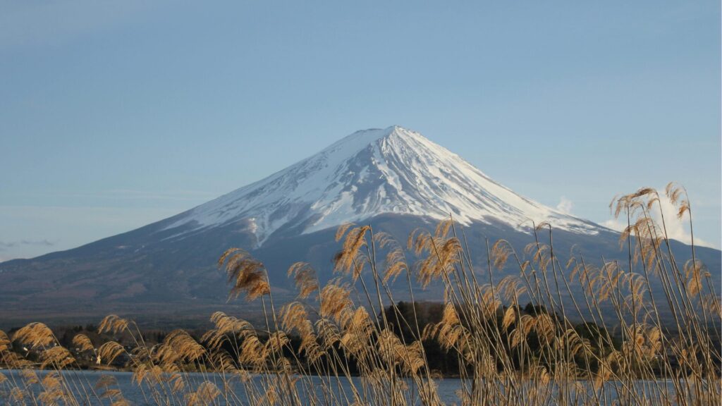
Mt Fuji — Japan's tallest peak at 3,776 meters (12,389 feet) — straddles the border between Shizuoka Prefecture and Yamanashi Prefecture on the main island of Honshu. Its exact summit coordinates are approximately 35.3606°N latitude and 138.7274°E longitude. Situated roughly 100 kilometers (62 miles) southwest of central Tokyo, Mt Fuji dominates the landscape of the Chubu region while remaining close enough to the Kanto region to be visible from the capital on clear days.
The mountain is not located within a single city or town. Instead, it spans multiple municipalities across two prefectures, with the northern slopes falling under Yamanashi Prefecture and the southern and eastern slopes belonging to Shizuoka Prefecture. This dual-prefecture identity is a key geographical fact that shapes how travelers plan their visits.
-

-
Mt Fuji: The Ultimate 2026 Guide to Japan's Iconic Mountain
Why Mt Fuji Captivates Millions of Visitors Every Year Mt Fuji — or Fujisan (富士山) as it is known in Japanese — stands at 3,776 meters (12,389 feet), making it the tallest peak in Japan. Its near-perfect symmetrical cone, capped with snow for much of the year, has been a symbol of Japan for centuries. In 2013, UNESCO designated Mt Fuji as a World Cultural Heritage Site, recognizing not just its geological significance but its deep influence on Japanese art, literature, and spirituality. Whether you want to climb to the summit, photograph the mountain from a picturesque lake, soak in ...
続きを見る
The Two Prefectures That Share Mt Fuji
Yamanashi Prefecture (Northern Side)
Yamanashi Prefecture encompasses the northern face of Mt Fuji, including the famous Fuji Five Lakes (Fujigoko) region. Lake Kawaguchiko, Lake Yamanakako, Lake Saiko, Lake Shojiko, and Lake Motosuko all sit at the mountain's northern base. This side is generally the most popular among international tourists because of its accessibility from Tokyo and the iconic views it offers — the reverse image of Mt Fuji printed on the ¥1,000 banknote was captured from the shore of Lake Motosuko.
The Yoshida Trail, Japan's most-climbed route to the summit, begins on the Yamanashi side at the Fuji Subaru Line 5th Station, which sits at approximately 2,300 meters elevation.
Shizuoka Prefecture (Southern and Eastern Side)
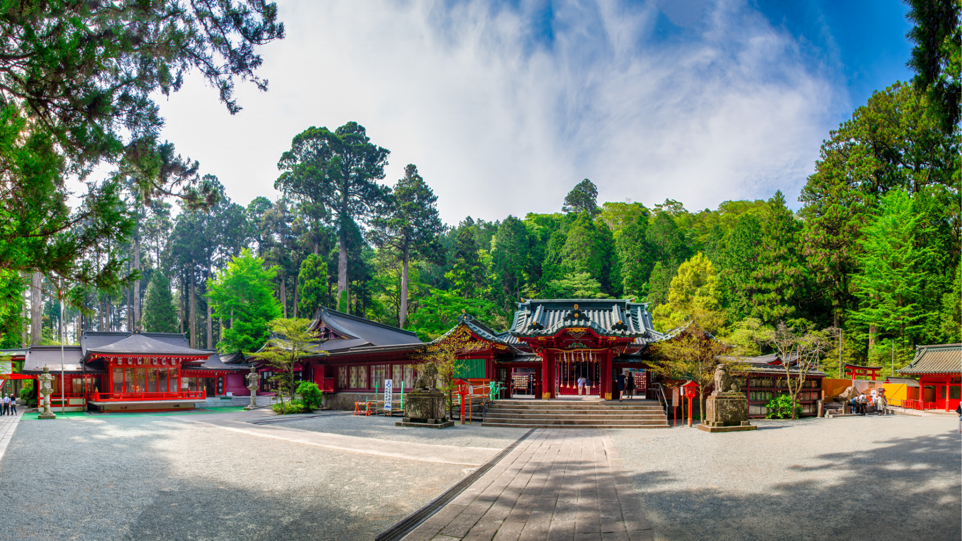
Shizuoka Prefecture claims the broader southern and eastern flanks of the volcano. Three of the four main climbing routes — Fujinomiya, Subashiri, and Gotemba — start from this side. The city of Fujinomiya is particularly well-known for its unobstructed views of the mountain and its connection to Fujisan Hongu Sengen Taisha, the head shrine of over 1,300 Sengen shrines dedicated to the deity of Mt Fuji.
The Shizuoka side tends to be quieter than the Yamanashi side and is favored by climbers who want a less crowded ascent, as well as by visitors seeking tea plantation scenery with Mt Fuji in the background.
How Far Is Mt Fuji from Major Cities?
Understanding the distance from major urban centers helps travelers plan their itineraries effectively. Here is a breakdown of approximate distances and travel times from key cities to the Mt Fuji area:
- Tokyo — approximately 100 km (62 miles). Driving takes around 1.5 to 2.5 hours depending on traffic and destination (Kawaguchiko vs. Gotemba). By train and bus, expect roughly 2 to 2.5 hours.
- Yokohama — approximately 80 km (50 miles). About 1.5 to 2 hours by car via the Tomei Expressway.
- Nagoya — approximately 180 km (112 miles). Roughly 2.5 to 3 hours by car or about 2 hours by Shinkansen to Mishima Station, then a bus connection.
- Osaka — approximately 350 km (217 miles). Around 3.5 to 4 hours by car or 2.5 hours by Shinkansen to Shin-Fuji or Mishima Station.
The relative proximity to Tokyo makes Mt Fuji one of the most accessible natural landmarks in Japan, and many visitors incorporate it into a day trip or overnight excursion from the capital.
Getting to Mt Fuji from Tokyo
By Train and Bus
The most common public transport route from Tokyo targets the Kawaguchiko area on the Yamanashi side. The JR Chuo Line runs from Shinjuku Station to Otsuki Station, where travelers transfer to the Fujikyu Railway line bound for Kawaguchiko Station. The entire journey takes approximately 2 hours. Alternatively, the direct Fuji Excursion limited express train runs from Shinjuku to Kawaguchiko without requiring a transfer, completing the trip in about 1 hour and 50 minutes.
For the Shizuoka side, the Tokaido Shinkansen from Tokyo Station to Shin-Fuji Station takes roughly one hour. From Shin-Fuji, local buses connect to various Mt Fuji viewpoints and the Fujinomiya 5th Station during climbing season.
Highway buses also operate frequently from Shinjuku Bus Terminal (Busta Shinjuku) to Kawaguchiko and Gotemba, offering a budget-friendly option at around ¥2,200 one way.
By Car
Driving to Mt Fuji from Tokyo offers the greatest flexibility, especially for reaching less accessible viewpoints, onsens, and surrounding attractions on your own schedule. The Chuo Expressway connects central Tokyo to the Kawaguchiko area in roughly 1.5 hours under normal traffic conditions. Alternatively, the Tomei Expressway leads to the Gotemba and Fujinomiya areas on the Shizuoka side.
Having a car is particularly advantageous for exploring the Fuji Five Lakes, visiting Oshino Hakkai, stopping at Subashiri, and accessing scenic spots like the Nihondaira plateau or Miho no Matsubara pine grove on the Shizuoka side. During the official climbing season (typically early July to mid-September), private vehicles are restricted on certain roads leading to the 5th Stations, so drivers must park at designated lots and take shuttle buses.
-
-
Drive from Tokyo to Kawaguchiko Onsen: The Ultimate Self-Drive Guide for Overseas Visitors
Planning to drive from Tokyo to Kawaguchiko onsen? This in‑depth guide covers routes, permits, parking, tolls, itineraries, and seasonal tips—everything you need to enjoy Lake Kawaguchiko and Mt. Fuji hot springs by rental car. Why Drive from Tokyo to Kawaguchiko Onsen? Driving gives you freedom to stop at scenic viewpoints, lesser‑known onsen ryokan, and cafés around the Fuji Five Lakes. Compared with trains and buses, a car lets you combine multiple sights in one day, travel early or late to avoid crowds, and carry luggage with ease. Quick Facts Distance & time: ~110–140 km from central Tokyo; 2–2.5 hours in ...
続きを見る
Best Places to See Mt Fuji
The location of Mt Fuji between two prefectures means there are viewpoints in virtually every direction. Here are some of the most celebrated spots:
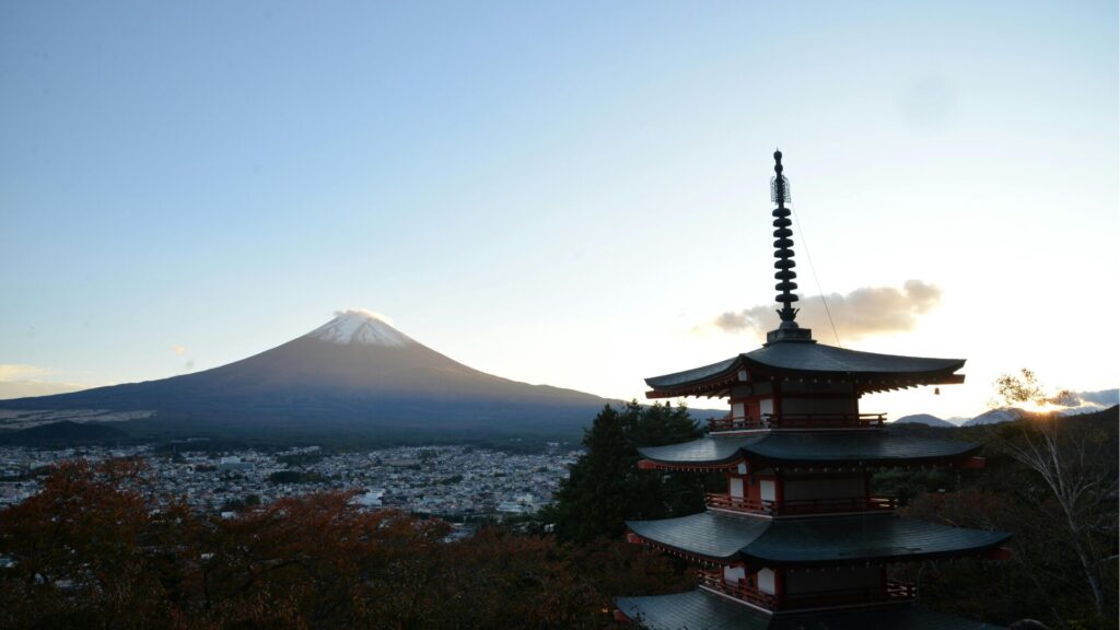
- Chureito Pagoda (Yamanashi) — Perhaps the most photographed Mt Fuji scene in the world. The five-story pagoda at Arakurayama Sengen Park frames the mountain beautifully, especially during cherry blossom season in spring and autumn foliage season.
- Lake Kawaguchiko (Yamanashi) — The most accessible of the Fuji Five Lakes, offering panoramic views of the mountain reflected in the water on calm mornings.
- Nihondaira (Shizuoka) — A hilltop plateau with sweeping views of Mt Fuji across Suruga Bay and the city of Shimizu below.
- Miho no Matsubara (Shizuoka) — A UNESCO-recognized pine grove along the coast where Mt Fuji rises dramatically across the bay.
- Gotemba Premium Outlets (Shizuoka) — A popular shopping destination that doubles as a surprisingly excellent Mt Fuji viewpoint on clear days.
- Hakone (Kanagawa) — Although technically in a neighboring prefecture, the views from Hakone's Lake Ashi and Owakudani are legendary, particularly with Mt Fuji as the backdrop.
-

-
Rent a Car Tokyo to Hakone Onsen: Complete Driving Guide for Visitors
Why Drive from Tokyo to Hakone Onsen? Renting a car gives you door‑to‑door access to hot spring towns, ryokan with private baths, and scenic viewpoints that are difficult to reach by train or bus. A car also lets you time onsen visits to avoid crowds, bring luggage without transfers, and combine Hakone with outlets, wineries, or Mt. Fuji photo spots in a single loop. When Is the Best Time to Drive to Hakone? Hakone is a year‑round destination. Weekdays outside national holidays are best for smooth traffic. Peak congestion times include Saturday mornings outbound from Tokyo and Sunday evenings inbound. ...
続きを見る
Can You See Mt Fuji from Tokyo?
Yes — on clear days, Mt Fuji is visible from numerous points within Tokyo itself. Winter months (December through February) offer the best visibility because cold, dry air reduces haze. Some well-known vantage points within Tokyo include:
- Tokyo Skytree observation deck — At 450 meters high, this is one of the best indoor spots to catch a distant view of Mt Fuji.
- Roppongi Hills Mori Tower — The rooftop Sky Deck provides clear western sightlines toward the mountain.
- Bunkyo Civic Center observation lounge — A free observation floor near Korakuen that offers Mt Fuji views on clear afternoons.
- Takao-san (Mt Takao) — Located in western Tokyo, this popular hiking destination provides excellent views from its summit, especially in winter.
During summer and the rainy season (June–July), clouds and humidity typically obscure the mountain. If spotting Mt Fuji from Tokyo is a priority, plan for early mornings in late autumn or winter.
Mt Fuji's Geographic and Cultural Significance
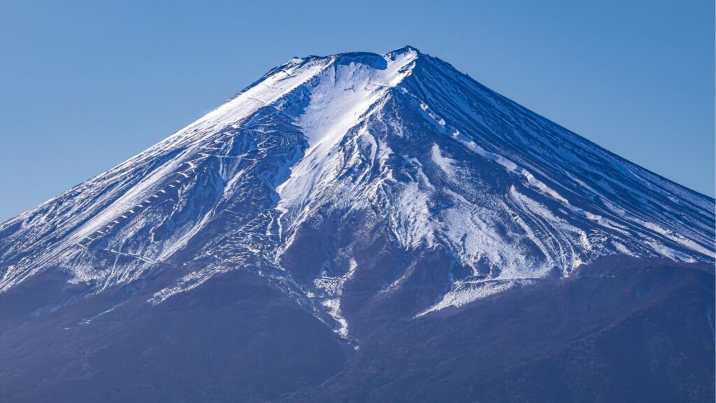
Mt Fuji is classified as an active stratovolcano, though it last erupted in 1707 during the Hoei eruption. It was designated a UNESCO World Cultural Heritage Site in 2013 — notably under the cultural rather than natural category, reflecting its profound spiritual and artistic importance to Japan. For centuries, Mt Fuji has been a sacred site for Shinto and Buddhist worship, and its symmetrical cone has inspired countless works of art, from Hokusai's iconic woodblock print series "Thirty-six Views of Mount Fuji" to modern photography and film.
Geographically, the mountain sits at the junction of the Eurasian Plate, the Philippine Sea Plate, and the North American Plate — a rare triple junction that contributed to its formation and impressive height. This tectonic setting places Mt Fuji within the larger volcanic chain that runs through central Honshu.
Nearby Attractions Worth Visiting
The area surrounding Mt Fuji is rich with attractions that extend well beyond the mountain itself. Many travelers combine a Mt Fuji visit with stops at neighboring destinations:
- Oshino Hakkai — Eight crystal-clear spring-water ponds fed by snowmelt filtered through Mt Fuji's volcanic rock over 80 years. Located in Oshino Village between Lake Kawaguchiko and Lake Yamanakako.
- Fuji-Q Highland — A major amusement park at the base of the mountain known for its record-breaking roller coasters and Mt Fuji views from the rides.
- Aokigahara Forest — A dense forest on the northwestern base of Mt Fuji, formed on hardened lava from an ancient eruption. Popular for nature walks and cave exploration.
- Hakone — A famed hot spring resort area about 25 km east of Mt Fuji, offering onsens, museums, and lake cruises with mountain views.
- Gotemba — A gateway city to Mt Fuji on the Shizuoka side, home to Gotemba Premium Outlets and several onsen facilities.
When Is the Best Time to Visit the Mt Fuji Area?
The ideal time depends on your purpose. Here is a seasonal breakdown:
- Spring (March–May) — Cherry blossoms frame Mt Fuji views at Chureito Pagoda and along the lake shores. Moderate temperatures make sightseeing comfortable, though the summit is still snow-covered and not open for climbing.
- Summer (June–August) — The official climbing season opens in early July. However, summer brings clouds and rain, often hiding the mountain from view at lower elevations. If summiting is your goal, this is the only window.
- Autumn (September–November) — Arguably the best season for photography, with vivid foliage surrounding the lakes and clearer skies returning by late October. Early snow may cap the summit, creating the classic postcard image.
- Winter (December–February) — The clearest views of a fully snow-capped Mt Fuji. Cold weather thins the crowds dramatically. Roads to the 5th Stations are closed, but the lower areas remain accessible by car.
Key Facts About Mt Fuji's Location at a Glance
- Country: Japan
- Island: Honshu
- Prefectures: Shizuoka and Yamanashi
- Coordinates: 35.3606°N, 138.7274°E
- Elevation: 3,776 meters (12,389 feet)
- Distance from Tokyo: ~100 km (62 miles) southwest
- UNESCO Status: World Cultural Heritage Site (since 2013)
- Volcano Type: Active stratovolcano (last erupted 1707)
Whether you are planning to climb Japan's tallest mountain, photograph it from a lakeside onsen, or simply catch a glimpse from the Shinkansen window, knowing exactly where Mt Fuji is located — and how the surrounding geography is organized — is the essential first step in planning your 2026 visit.
Experience Japan’s Finest JDM Adventures
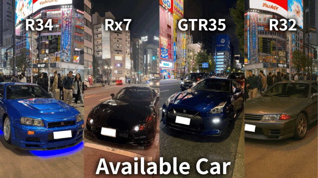
From Daikoku PA tours to JDM sports car rentals and drift experiences, we offer premium driving adventures for visitors who want more than ordinary sightseeing.
Get behind the wheel of iconic machines such as the GT-R, RX-7, and Supra, and experience Japan’s legendary car culture in the most unforgettable way. Whether you want a scenic Tokyo car experience or something more thrilling and immersive, we can guide you to the right plan.
Not sure which experience suits you best? No problem. Message us on WhatsApp and we’ll help you choose the ideal option based on your travel plans, interests, and driving experience.
Popular dates sell out quickly, so we recommend contacting us early.
Customer Reviews

Important Information
- This is a drive tour where you drive your rental car, and our guide navigates from the seat.
- This is a self-drive tour where you drive your rental car, and our guide navigates from the passenger seat.
- The tour begins and ends at the same location (Shibuya).
- If the Daikoku Parking Area is closed, we will instead guide you to another car meet further away.
- The consultant is a cultural expert and navigator, not a taxi service.